The Tibetan Plateau is a geological splendor that attracts people from all walks of life yearly. Geologists, mountaineers, and enthusiasts are intrigued by its unique location, exceptional size, and role in Asia’s story. This plain is also critical to Tibetan ancestry, religion, and livelihoods. What else makes this marvel special? Why is it known as the Roof Of The World? Read on to discover several interesting facts about its location, cities, vegetation, and how the earth created it eons ago.
What Is Tibetan Plateau?
The Tibetan Plateau is the largest and highest elevated plane in the world. It spans 970 000 square miles of space, is 1,600 miles long, and 620 miles wide. It’s comparable to five times the size of modern France. Most of it lies in the Tibetan region, hence its name. The Chinese refer to the plateau as Qinghai-Tibet or Qing-Zang, while Indians call it the Himalayan plateau.
The plateau is an integral part of China’s history because the Gansu or Hexi corridor of its main-silk trade route ran through it. Sometimes, geologists refer to it as the earth’s Third Pole because its ice fields closely rival the largest freshwater reserves in the North and South pole.
Where Is Tibetan Plateau Located?
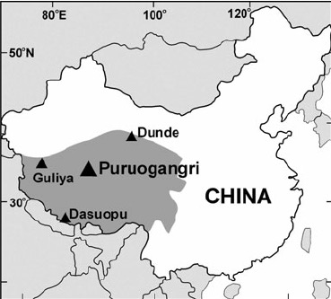
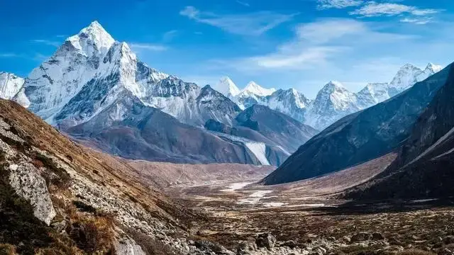
The Tibetan Plateau is in Eastern, Central, and Southern Asia. Significant mountain ranges surround and nest this plateau; the Kunlun Mountains to the North, the Chinese Qilian Mountains to the North East, and the Himalayan range to the South. The rugged Kashmir Karakoram mountain ranges border the plateau to the west, while it embraces a remarkable water tower on its eastern side. This unique location makes the Tibetan Plateau a geographic wonder!
What Created The Himalayas And The Tibetan Plateau?
The history of the Tibetan Plateau closely relates to the Himalayas mountains. According to experts, such a plateau results from a tectonic force called crustal shortening that creates mountain ranges. The collision between the Eurasian and Indo-Australian plates created these magnificent mountain ranges and the Tibetan Plateau that replaced the Tethys Ocean.
The earth’s crust faulted, folded, and thickened at compressed points to move the Himalayas upwards while it made the thickest plateau on earth. Interestingly, the force pushes it upwards at approximately 5mm yearly, but erosion slows down this height increment.
What Animals Live In The Tibetan Plateau?
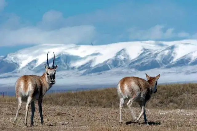
The Tibetan plateau is home to some rare species; the white-lipped deer, Mongolian gazelle, yaks, snow leopards, blue bears, Thorold’s deer, and Tibetan antelopes. Blue sheep and the toxic high jumping spider are exclusive to this plateau. The rarity of these species endangers their existence as people hunt them for their antlers, skin, and wool. Most of these animals are under state protection to avoid extinction. Wolves, foxes, kiangs, and lynxes are some of the common animals in the region. Animals on the plateau have adapted to the cold conditions and thrive in such weather.
Why Is The Tibetan Plateau Called The Roof Of The World?
The Tibetan Plateau is known as The Roof Of The World because it’s nestled between two of the highest summits, Mt. Everest and K2, among other outstanding ranges, with an elevation that exceeds 14500 feet. The phrase is a general metaphor for this mountainous region because of its significantly high altitude. The earliest reference to the plateau in this sense was in the early 1800s when explorers started their tours.
Why Is The Tibetan Plateau Important?
The Tibetan Plateau is an essential water tower for Asia. Its thousands of glaciers are the source of the three longest rivers in the region, the Mekong, Yellow, and the Yangtze, among other major rivers. The plateau also has more than 700 lakes; they account for 30% of the lakes in China. These headwaters are Asia’s lifeline.
How Old Is The Tibetan Plateau?
According to geologists, the tectonic shifts that created the Tibetan Plateau started 70 million years ago. The Indo-Australian and Eurasian plates collided and thrust 15cm of the earth’s crust upwards annually. Fifty million years ago, the process displaced the extinct Tethys Ocean. 13.5 million years ago, the forces eventually yielded what we know now as the plateau.
How High Is The Tibetan Plateau In Feet?
The Tibetan Plateau is approximately 14500 feet high. Notably, the plateau has flatness or low relief due to two assumptions; some geologists believe it was initially a peneplain that tectonic forces pushed upwards, while others argue it is a result of erosion.
How Do People Live In The Tibetan Plateau?
The Tibetan Plateau and its surrounding mountains are unforgiving for anyone who dares conquer them, so how do locals survive on it? The Tibetan population and their bodies acclimate to the plateau’s conditions. According to scientists, Tibetans have a natural knack for living in this low oxygen area because their blood vessel linings produce high amounts of nitric oxide. This nitrogen gas produces nitrates and nitrites that expand their blood vessels to deliver oxygen-rich blood throughout the body faster.
Although nitrogen in the human body is a cause for alarm, it has no adverse effects on Tibetans. Tibetans also breathe much faster than usual to meet their oxygen requirements. This medical change makes Tibetans immune to high-altitude hypoxia and its related sickness. The adaptation also means these people cannot live in lower altitudes.
Tibetan Plateau Population
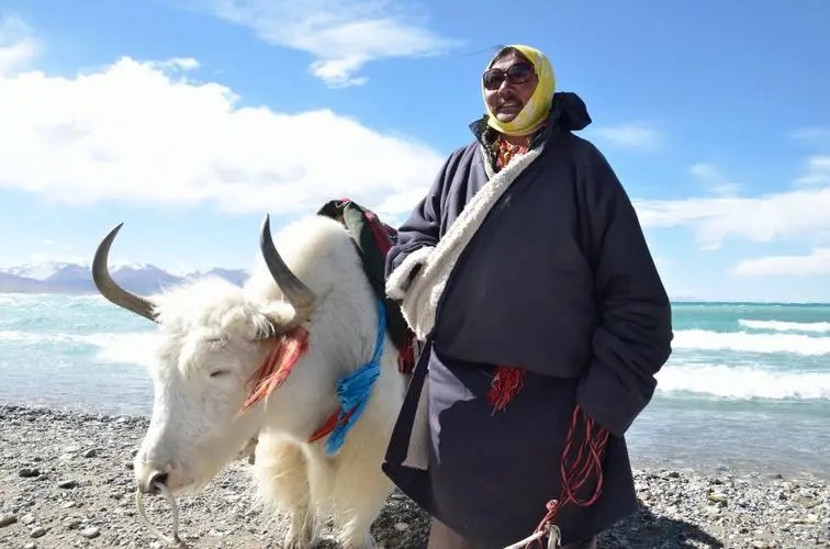
The Tibetan Plateau is home to approximately 4.5 million people; most of them are ethnic Tibetans who descend from the empire that inhabited the region thousands of years ago. Although the Tibetan government is yet to release official data about its population size, historical sources suppose its people are the majority in this area. Some ethnic Han Chinese and Mongols are a minority that also lives on the plateau.
Due to its high mountains, desert terrain, and low oxygen, the plateau is mainly uninhabitable, so non-ethnic groups opt to live at the foot of its mountains. The Tibetan population embraces nomadism because its grassland vegetation suits their lifestyle; its terrain barely supports crop farming unless it’s on lower altitudes. They eat barley with meat products, dress in traditional woolen attire, and practice Buddhism.
Tibet Qinghai Plateau Vegetation
Vegetation on the Tibet Qinghai Plateau is partly tundra, shrublands, forests, and vast grassland with some rare species. The area has a low variety of plant species due to dry weather. The plateau experiences less than 600mm of annual precipitation because the Himalayas block humid monsoon winds from the Indian Ocean and such high altitudes usually translate to aridity. This climate and weather barely support diverse plant growth.
Central Tibet has diverse grasslands like the most famous Changtang, steppes, and shrubs. The Southeast side also has greener grassland, while its desert part at the Kunlun Mountains has prickly and saline shrubs. Gobi deserts on the plateau are known as the land of no life because of their extreme weather conditions. Notably, the southeastern side of Tibet has protected coniferous forests like the Lulang because some narrow valleys let in monsoon winds that cause ample rainfall. Fortunately, various government authorities have protective vegetation laws, especially for indigenous and precious varieties.
Tibetan Plateau Cities
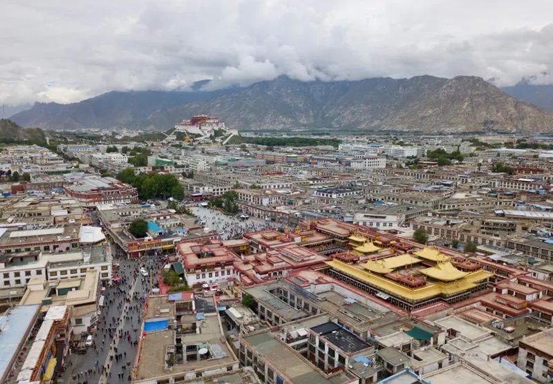
Tibet has ten remarkable cities that hold a rich history i.e.
- Lhasa
- Shigatse
- Gyantse
- Tsetang
- Bayi
- Chamdo
- Naqgu
- Shiquanhe
- Gyirong
- Xarsingma
Lhasa, the plateau’s capital city, is known for warm weather, monasteries, and the Potala Palace. Shigatse is home to the highest summit, Everest, and the largest monastery in the world, the Rongbuk. The first Dalai Lama also built Tashilhunpo Monastery Shigatse, and its Sakya Monastery is the center of Tibetan history. Gyantse has a history of heroic aggression against the British invasion, while Tsetang was a civilization hub. Bayi is famous for its extensive ancient forest of cypress trees, and Chamdo preserves Tibetan Kham culture.
Naqgu hosts a famous horse-racing festival, produces a quality herb medicine known as caterpillar fungus, and holds China’s second-largest saline lake, the Namtso. Tibet’s gobi deserts, sacred lakers, and oldest monasteries are in Shiquanhe. The scenic alpine-valleyed Gyirong overlooks the breathtaking Himalayas, and Xarsingma is a busy historical trade center.
Conclusion
Seventy million years ago, the earth’s tectonic forces shifted and created the Tibetan plateau. Today, it is essential to Asia’s existence because it is the sole water source for areas like the Yellow Plain. It borders significant mountain ranges like the Himalayas and Everest, with a relatively low population. The plateau has several notable species of plants and animals that adapted to living in its cold arid conditions; some are indigenous. Tibetans exhibit a similar adaption because their bodies can easily survive hypoxia. The region’s cities are rich in history, culture, and religion that are worth a visit.