Yangtze River is one of the modest geographical features of China. It runs across China and hosts many communities offering them economic help along its way. It is one of the most important features of ancient and modern-day economics in china.
What is the Yangtze river?
Yangtze River is the third-longest river in the world and is also known as Chang Jian. It is the largest river in Asia and also the longest river in the world to run through one country. It has eight major tributaries along its course. The tributaries are:
- The Yalung
- The Min
- The Jialing river
- The Han rivers
- The Wu river
- The Xiang river
- The Yuan river
- The Gan rivers
The Yangtze river covers a total distance of 6300 kilometers from start to end and has 6000 meters fall in altitude. It also boasts the deepest depths in a river in the world.
Where is the Yangtze river?
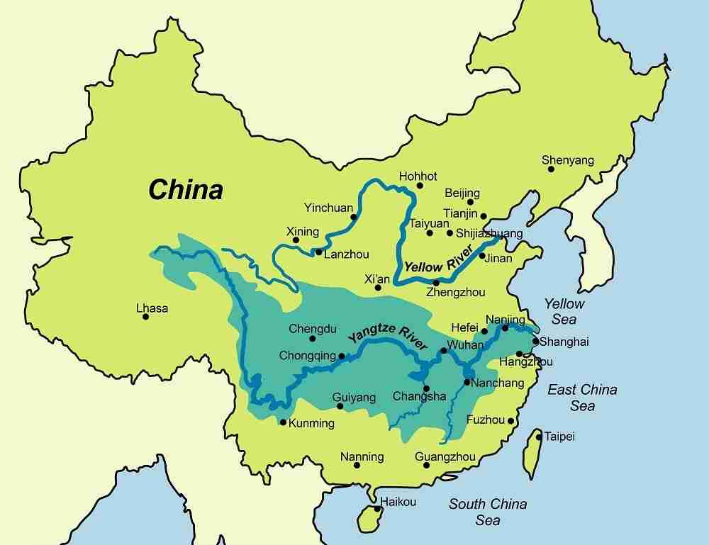
Yangtze River is located in china. It is used as a border in more than nine provinces of China. These provinces are Qinghai province, Tibet province, Sichuan province, Yunnan province, Hubei province, Hunan province, Jiangxi province, Anhui province, and Jiangsu province. Its basin covers about 3200 kilometers from north to south and about 1000 kilometers from east to west. The basin host about one thirst of the total population.
Where does river Yangtze start and end
Yangtze river starts from the Ulan Moron river which originates from the glacial meltdown of the Tanggula Mountains in Qinghai province at the Tibetan region border. It flows across the Tibetan plateau and down the valleys of the mountains east of the plateau. It flows eastwards through the Yungui plateau where there are small lakes and reservoirs.
The river changes course and flows southwards from a high elevation when it reaches the Bayan Har mountains. It runs through steep rocky slopes and valleys that are up to three kilometers in depth. For about 400 kilometers the river runs parallel to rivers Mekong and Salween until river Yangtze diverges east through steep rapids and merges with river Yalong which contributes most of the water. At this point, the river is about 1000 feet above sea level.
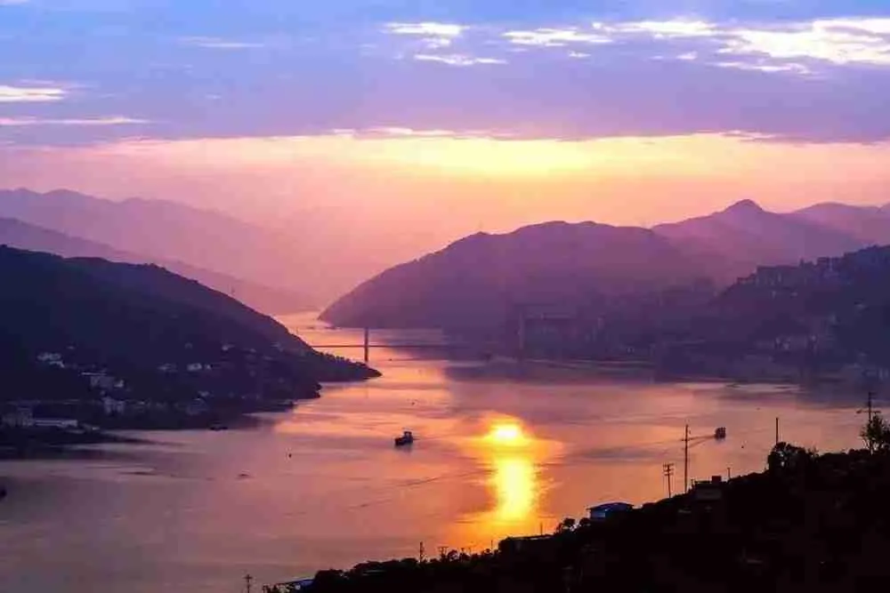
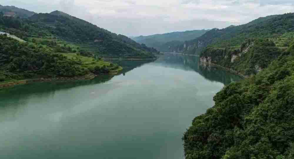
The river continues to flow through eastern Sichuan to western Huaibei and reaches the 3 gorges region. This is where the Three Gorges Dam was built. It flows through Qu tang gorge for about 8 kilometers onto another 50 kilometers of the Wu gorge and finally about 45 kilometers of the Xiling gorge. The gorges are narrow and were considered hard to navigate due to many rapids and about 180 meters of depth making the River Yangtze the deepest river in the world.
The Yangtze leaves the Three Gorges Dam near Yichang and goes through several lakes, marshes, and river channels in the province of Hanan and Hubei. This is the region where the Yangtze meets the major tributaries Han, Xian, and the Yuan. It flows through many lakes like The Dongting lake and then widens remarkably. Here the river is about 800 meters wide, 30 meters deep, and has a flow rate of 1 meter per second.
It flows near Wuhan metropolitan on the left and Wuchan on the right then continues into the plains of Jiangxi province. The Yangtze receives the Kan river tributary and flows out to the southern part of the North China plains. Its width by now is about 1800 meters and passes the cities Wuhu, Anqing, and Nanjing onto The Grand canal which is one of the world’s longest canals covering a distance of about 1800 kilometers.
River Yangtze forms a delta near the city of Zhenjiang consisting of many branches, lakes, and marshes. The width of the delta is about 3.2 kilometers and widens further downstream when it forms an estuary with a width of about 80 kilometers near the river’s mouth. It passes through major cities like Shanghai, and Wuxi before it divides into major parts that drain independently into the East China sea.
What is river Yangtze used for?
Yangtze River has many uses in different communities. The major uses are agriculture and fisheries.
Agriculture in the Yangtze basin
The land of plenty found in east Sichuan is a place where every aspect is favorable for agriculture. From fertile soils to the mild climate that the area has, it has grown to be an agricultural hub that influences China’s crop production. The Yangtze basin produces almost half of china’s produce with rice production hitting two-thirds of the whole of China’s production. Other crops produced in the region include corn, barley, wheat, hemp beans, and cotton. Fine Silk is also produced in great volumes in this region. During drought periods, the Yangtze provides water for irrigation and this has seen many irrigation projects such as The Three Gorges Dam being built.
Fisheries and the river Yangtze
River Yangtze has seen fishing as major economic activity including artificial and natural fishing. There are over 30 species of fish that are desired economically that exist naturally in this river. Some of the fish types include but are not limited to: Chinese perch, gapers, carp, lamprey, and bream. These are sourced in the many lakes attributed to the river Yangtze and the man-made dams along the river. The gorges are used as spawning areas and fingerlings collected are then distributed to other regions for artificial farming. The most desirable species are white and black Amur of the carp family and the flatfish.
Why is the river Yangtze important to China?
River Yangtze is important to China due to its enormous size which makes it navigable by large motorized vessels. Since it passes through several provinces, it is used as an inland navigational route. Most of these provinces are advanced industrial cities that need a reliable connection to open seas as most of the goods are for export. About 2700 kilometers of its length experience heavy cargo and human traffic reducing dependency on road networks and making this river a major inland route.
With the big population in the river Yangtze basin, a larger population depends directly on the river for economic purposes be it farming, fishing, transportation, or navigation from one place to another. As seen above the agricultural aspect of the river means that the larger china depends on the river for agricultural produce.
Even though not fully developed, the river is estimated to be able to produce 200 million kilowatts which would be about two-fifths of China’s total energy needs. River Yangtze hosts several hydroelectric plants the largest being The Three Gorges Dam which covers about 600km upstream and can produce 22,500 megawatts of power. The second-largest project and the first to be made was the Ghezouba hydroelectric dam near Yichang. Many Yangtze tributaries such as the Min, Jialing, and the Yalong rivers have significant falls with great production potential.
Why does the Yangtze river flood?
Over time the Yangtze has recorded a series of serious and devastating floods in the flood plain of the Yangtze valley. In 1931, a series of deadly floods were recorded. These floods claimed about 4 million lives. It is on record that it is one of the world’s deadliest natural disasters of the 20th century.
In 1954, the river basin experienced a very unusual amount of rainfall making the river rise above normal levels and causing devastating floods again. About 33,000 lives were claimed by the floods and many were left homeless.
Another flooding incident occurred in the summer of the year 1998 and brought about US$26 million in damages. This was also attributed to higher than usual rainfall that summer.
The heaviest recorded rainfall in 41 years was recorded in the year 2020 and again flooding occurred. This increase in rainfall was attributed to a reduction of aerosols and emissions from the industry due to the Covid-19 shutdown. The government was forced to put laws controlling emissions to prevent future occurrences.
Difference between the yellow river and the Yangtze river
The Yangtze is the largest and the yellow river comes in second. There are many notable differences between them like their size, flow rates, flow regions, and climate around the two basins. The differences are best shown in the table below.
| River Yangtze | Yellow River | |
| size | Total length is 6300 kilometers | Total length is 5464 kilometers |
| Elevation | Falls through 6000 meters of altitude | Falls through 4000 meters of altitude |
| Precipitation | Receives about 1100mm of rainfall per year.Rain season from July to August | Receives about 650mm of rainfall per year.Rain season from June to September |
| climate | Temperatures of about -4 degrees at the source and up to 40 degrees downstream | Temperatures of about -4 degrees at the source and 14 degrees downstream |
| drainage | Drains into East China sea | Drains into Bohai sea |
Conclusion
The Yangtze is seen as a great geographical feature as it supports a very high population in China. It has major contributions to china’s trade routes due to its connection of inland to seaports. We can also see the river’s key role in feeding the population.
